- Home
- News / events
- Avenue Road
- Biggin
- Buckingham Road
- Census 1841
- Chapels
- Charities & poor relief
- Church
- Church Street
- Directories / descriptions
- Enclosure
- Families / people
- Farms
- Fire insurance
- High Street
- Horn Street
- Maps
- Market Square
- Medieval & 16th century
- 19th-20th Centuries
- Oral history
- Parish Council
- Photographs
- Pubs
- Railway
- Redfield
- Schools
- 17th-18th Centuries
- Sheep Street
- Shipton
- Station Road
- Tanneries
- Tinkers End
- Turnpike
- Vicarage & Verney Roads
- Western Lane
- Wills
- Windmill
- Winslow Hall
- Workhouse / Hospital
- World War One
- Sitemap
- Links
- Search site
- About us / contact

Farms
Medieval Winslow was an intensely arable landscape, with very little meadow or pasture and no significant woodland. There were three huge open fields (and three more in Shipton), divided into furlongs, which were divided into ridges and furrows. This was still the case when the Fortescue Map was produced in 1599. Many of the furlongs in Shipton are listed in a document of 1633. A document listing a holding of at least 90 acres from c.1635 shows how scattered and unconsolidated individual pieces of land still were at that date, although it shows the start of a trend away from arable farming. Some indication of the range of crops grown can be seen in this retirement agreement of 1345:
| And there is a condition that the aforesaid Agnes, daughter of John Mayn, will pay annually to the aforementioned Geoffrey May between Michaelmas and Martinmas, for the term of Geoffrey's life, 5 quarters of grain with one bushel of oats: namely, one and a half quarters of wheat, one and a half quarters of barley and 2 quarters of beans and peas of the better crop growing on the aforesaid land. |
This shows that, although the principle of the three field system is usually stated to be one field for wheat, one for another crop and one fallow, in practice the cropping system was considerably more complex.
Winslow was an important agricultural market centre. There was a weekly market on Thursdays, and Owen's New Book of Fairs (1813) lists these fairs: "March 20, Holy-Thursday, Aug.21., Sept. 22 cattle. 1st and 2d Thursdays after Old St. Michael, Oct. 10, for hiring servants."
After Enclosure, there was a complete change in farming practices (although the trend probably began earlier). Rev. St.John Priest, A General View of Agriculture in Buckinghamshire (1813), p.372 records the acreage in Winslow as:
- Meadow 719
- Pasture 1459
- Arable 300
- Heighton's (William Matthews, excise officer; this was near Great Horwood Road, and bought by William Selby Lowndes from Edmund Heighton in 1865 and added to Redfield - Centre for Bucks Studies, AR28/90)
- Magpie (William Alderman, labourer)
- Mobbs's (John Burrell, labourer; this was formerly Dudlow and later Redfield)
- Red Hall (John Woodward)
- Shipton (John Bull) - this is called Bridge Farm and Whitehouse Farm on earlier maps
- Tuckey (Samuel Cole)
- George Maydon, living in the High Street: maltster and farmer of 80 acres employing 5 men
- James Hawley of 6 High Street: grocer and farmer of 218 acres employing 2 men & 2 boys
- John Curtis of 47 Sheep Street: farmer of 147 acres employing 8 men
- William Walters of Johnsons Farm, Sheep Street (south side - presumably this was Shipton Farm): agricultural bailiff of 118 acres employing 5 men
- Rosetta Neal of The Bell: occupier of 84 acres employing 5 labourers
- Thomas Edwin of Rands Farm: farmer of 210 acres employing 5 men & 1 boy
- Ann Burgess of Swanbourne Road: grazier of 26 acres employing 1 man
- John Woodward of Redhall Farm: farmer of 193 acres employing 7 labourers
- Magpie Farm occupied by George Willmore, agricultural labourer
- George Mayne of Buckingham Road (= west side of High Street, where the Post Office was later built): farmer and brickmaker of 120 acres employing 10 labourers
- Robert Jones of Horn Street (later The Manse): farmer of 155 acres employing 7 labourers
- Joseph Bowden of Horn Street: farmer of 50 acres employing 1 man
- Samuel Cole of Tuckey Farm: farmer of 301 acres employing 11 labourers
And describes the effects (p.414) as "Cows, butter, and fat hogs, increased; sheep decreased; grain of all kind decreased". When the Winslow Hall estate was sold in 1897, out of 1,399 acres in Winslow and adjacent parishes, only about 107 were described as arable. Dairy-farming now predominated, and this remained the case until the Second World War, when some of the meadow and pasture was ploughed up (see Farming in World War 2). Nevertheless, the amount of surviving ridge-and-furrow all around Winslow shows the limits of the arable revival, although much of it has now been lost to housing.
The effects of enclosure on the poor were described by Frederic Morton Eden, The State of the Poor vol.2 (1797), p.30:
Farms are from £60 to £400 a year. About 200 acres are arable-land, and cultivated with wheat, beans, and oats: the remainder of the parish is grass-land. There are no commons. In 1744. a hamlet belonging to the parish, containing about 400 acres, was enclosed; and in 1766 the other part of the parish was enclosed. Upon the enclosure of the open fields, land was given in lieu of tithe. The rise of the [Poor] Rates is chiefly ascribed to the enclosure of common fields; which, it is said has lessened the number of farms, and, from the conversion of arable into pasture, has much reduced the demand for labourers. An old man of the parish says, that, before the enclosures took place, land did not let for 10s. an acre, and that, when he was young, the name of roundsman [=casual labourer looking for work] was unknown in the parish. It must however be considered, that, now a great part of the labour done in the parish, is paid for, out of the Poor's Rate, in money, given to roundsmen [=the Speenhamland system of subsidising low wages]. The rent of land is from a guinea to £2. 15s. an acre. The land-tax, (now at 7s. 6d. in the pound,) produces £233. 17s.
According to Priest there were 12 farmhouses in Winslow at the time of his survey. These probably include Blake House, the eight farms recorded in 1841 (see below), the house which subsequently became Sunny Lawn House, and two other houses in Horn Street, Sheep Street or Shipton.
There was still enough arable farming for special arrangements to be made for selling corn at Winslow market in 1824 (Windsor and Eton Express, 27 Dec 1823). A pitched corn market was one where all the grain for sale was brought to market, not just a sample.
|
WINSLOW PITCHED CORN MARKET. WHEREAS many and repeated complaints have recently been made by various Agriculturists and others, of the very serious inconvenience they have long experienced from the very objectionable custom of selling CORN by sample at WINSLOW MARKET; and also in consequence of having fully effected every necessary convenience with extensive accommodations for pitching and storing of Corn in the central part of the said Town; but more especially from the very decided preference given to trading in Corn by Bulk, both by the Growers and Buyers in this Neighbourhood. Notice is Hereby Given, That we whose names are hereunder signed have commenced our endeavours for effecting so desirable an object, and will pitch our Sample Sacks of Corn at Winslow Market on Thursday, January 1st, 1824: |
|
| JOHN BULL MARY BULL THOMAS CRIPPS GEORGE CROSS WILLIAM CORBETT JAMES DOVER EDWARD DANCER THOMAS FLOWERS JOHN FLOWERS EDWARD FLOWERS ANN HARRIS JOHN HORN JOHN HARRUP THOMAS JONES THOMAS KING GEORGE KING WILLIAM KING HENRY LINES |
JAMES MUMFORD JOSEPH NEALE ROBERT PARROTT ELIZABETH READ RICHARD ROADS THOMAS RIDGEWAY THOS. RICHARDSON JOSEPH STEVENS BENJAMIN STEVENS JOHN SHORT ROBERT TOMKINS WILLIAM TOMKINS JOHN TURVEY THOMAS VICCARS JOHN WILLETT J. D. WILLIAMSON F. WARNER L. WYATT & MAYDON |
N.B. By permission of Wm. SELBY-LOWNDES, Esq. Lord of the Manor, the above Market will be Toll-free for two or three Years. The Corn Market will commence at 12 o’Clock. |
|
In the 1841 census, these farms are listed by name:
Rands Farm (Thomas Edwin) and Curtis's Farm (John Curtis; now 47 Sheep Street) can also be identified. Two farmers had houses on the north side of Horn Street (Charles Monk, Robert Jones), and three more were listed in Shipton (Joseph Bowden, William Archer, Thomas Burgess) - these houses were not necessarily used as farmhouses.
The 1851 census shows that enclosure did not affect the landscape of Winslow as much as most of North Bucks. Only 3 farmers lived on farms in the middle of their land. The others lived in the town or in Shipton, and some combined farming with other occupations. It lists:
See the following links for information about some of the farms:
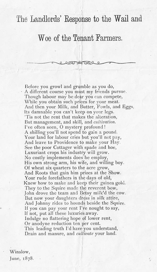
This poem, written in 1878, gives some idea of what people were saying during the Victorian agricultural depression. It was found among the papers of W.N. Midgley but he can't have been the author. Another poem on a similar theme was published in the local press in 1879: click here.
Winslow RDC started its own Sewage Farm in Granborough Road in 1905, using nearly 6 acres of land around the filter beds to grown fodder crops. Read more.