
High Street
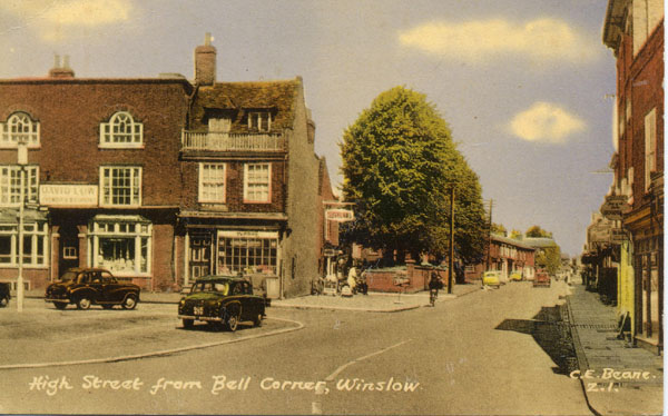
The name High Street is relatively recent. Until the 19th-century northward expansion of Winslow, the street from the Market Square to Greyhound Lane was known as Cow Street. The road leading north from that was known at first as Union Street (after the Workhouse) or Buckingham Road. In the early 20th century the whole road from the Market Square to Station Road began to be called High Street, and the Parish Council in 1910 decided that this should be made official. Before the mid-19th century the last house on the west was Sear's coachbuilders (site of the telephone exchange) and the last house on the east was the original Workhouse, later Benbow's.
- The Royal Oak (2A High Street)
- 6 High Street
- 8 High Street
- 12 High Street
- 14 High Street (Royal Oak c.1699-1795)
- 16 High Street
- 18-20 High Street
- 22 High Street (Three Pigeons until 1775)
- 24 High Street
- 26 High Street: King's Head (formerly Sow and Pigs)
- 28-30 High Street (The Elms, Black Bull)
- The Three Pigeons (27 High Street) and 29-31 High Street
- The Greyhound (Hare and Hounds)
- Greyhound Lane tannery
- The Windmill Inn (33 High Street)
- Arundel House (35 High Street)
- High Street north (west side): Sear's and Coxill's
- Sale of land east of the High Street, 1886
- The Chandos Arms and Rose Cottages
- Old 82-86 High Street
- 89-115 High Street & the Royal Engineer
- The Stag Inn (166 High Street)
- Workhouse
- Public Hall / Oddfellows Hall
- Recreation Ground / Bell Closes / Tabernacle Field
- History of the British Legion Hall by Alan Wigley (PDF, 113KB)
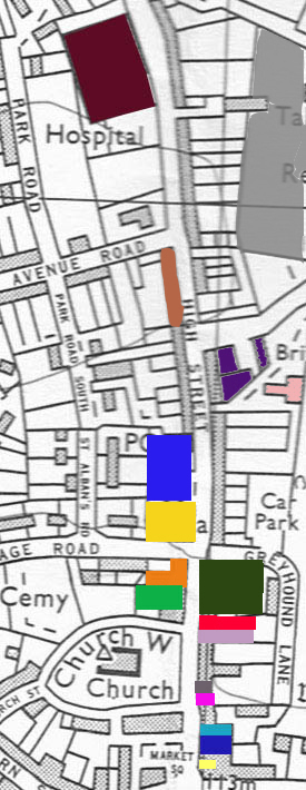
Click on the map below for links:
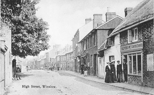
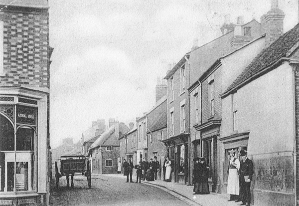
The postcard below was posted in 1915 but the image must be earlier than 1911. Benbow's shop is front right (replaced in 1926 by nos.56-58), and the white building next to it was the original workhouse. Beyond that is the shop which is now the Co-Op (Manchester House). The scene beyond it has changed a lot due to the plane crash in 1943 and the fire at Gibbards' in 1933. On the left, the Post Office was built in 1911 where the large tree is standing. On the far left is the gateway and workshop of the Sear family of coachbuilders, formerly the north end of the town. See A.J. Clear's lecture in 1932 for more information.
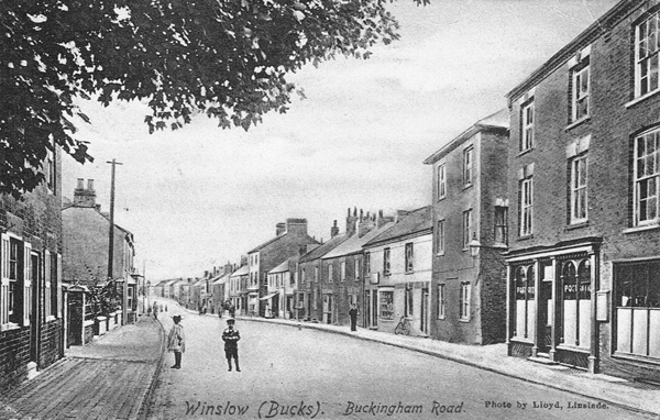
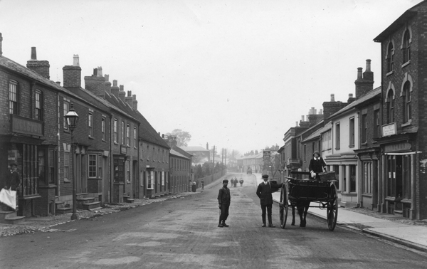
The view below was taken slightly further north, underneath the tree which you can see in the photo above. The postcard was posted in 1907. On the right is the Post Office in the shop previously run by the Loffler brothers. The two buildings to the left of it are still there, but beyond that is the Chandos Arms, destroyed in the 1943 plane crash, and the site which is now the end of Elmfields Gate. On the left, the telephone pole stands immediately in front of the end of 73 High Street, and the front gardens of numbers 65-71 are visible. This was the site of the gasworks 1843-1880, and the building on the left edge of the photo could have been the manager's house. It was demolished soon after the photo was taken and replaced by no.63. No.61 and the adjacent purpose-built Post Office were added in 1911.
The postcard below was posted in 1905. It shows the High Street immediately to the south of the photo above; Benbow's shop in the foreground above is the thatched building whose gable end can be seen in the background below. On the right are 34-54 High Street. The first references to buildings on the site can be found in the court rolls of the 1680s, and no.42 (now Brian Clark Opticians) largely avoided 19th-century remodelling. The building on the far right, whose frontage has been completely altered, is now Oak Park Alarms. In 1905 it was Miss George's stationery shop. Other shops included a butcher's, fishmonger's and barber's. On the left is the Victorian building called Arundel House, formerly the Winslow Commercial School, but used by Matthews Brothers builders at the time of the photo.
The west side of the High Street north of Vicarage Road developed in this order:
- 1835/6: Workhouse
- 1841: Boys' School
- 1842/3: Gasworks
- from 1843: 75-87 High Street
- 1846/7: 89-115 High Street & Royal Engineer
- 1880: Gasworks moved to Station Road (replaced by 61-73 High Street)
- 1904: Boys' School moved to Sheep Street (replaced by Post Office)
The buildings on the right of the photo below were largely destroyed in the fire of 1933. The sign on the 3-storey building on the far right is for W.J. Sirett, cabinet-maker and upholsterer. His business was for sale in January 1913 ("very cheap", "small stock"), so the photo must be earlier than that, but no earlier than 1909 (see below). Above the head of the man standing by the cart, you can see the sign of the Golden Lion (160 High Street). On the left in the middle distance are the 14 cottages (89-115 High Steet) built by Samuel Boneham (see below) in 1846-7. At the far end of the row you can just see the higher roof of the former Royal Engineer, which was a beerhouse from 1847 to c.1884. Photo from the collection of the late Ruth Hall MBE.
Occupiers of nos.89-99, which were built first, according to Samuel Boneham's insurance policy, 22 Sep 1846: Samuel Boneham, Thomas Goodger, Richard Dumbleton, James Tuckey, Richard John [?=Soden] and John Dumbleton
Occupiers of nos.89-115 according to the 1847 manor court: 1 unoccupied, others in the occupation of John Dumbleton [93], Richard Soden [95], James Tuckey [97], William Lomath [111], William Goodyer, John Barge, James Horn, Mark Bunce, George Verney, Samuel Boneham , Charles Goodman [113], Philip Harris, John Cooper and Thomas Archer.
The pavement on the left of the photo was laid in 1909:
1909: Buckingham Advertiser, 13 Nov: Winslow RDC
A letter was received from the Winslow Parish Council enclosing a recommendation from that body that the west side of the High Street should be paved with blue bricks at the cost to Winslow of £10.
Mr. Illing said he had been in communication with the County Surveyor and the Parish Council, and he now moved a proposition to the effect that the County Surveyor be asked to carry out the work in accordance with an agreement, and he should like it to be done without any misunderstanding this time, and that the new pavement should extend from Mr. Wise’s [no.63] to Avenue Road, and that old bricks be used as far as possible and that new bricks be used for the remainder, and that the cost to the special fund of Winslow does not exceed £10. He should like it to be definite this time. Mr. Monk was unable to attend the present meeting and had asked him to move the proposition, which he had pleasure in doing. He might add that it was the general opinion that blue bricks would be preferable to asphalte, though the latter would only cost £8.
[editorial] Thanks to the energy of Messrs. Monk and Illing, a proper footway, which has for many years been so badly wanted, on the west side of Winslow High Street, will shortly be an accomplished fact, and Winslow ratepayers may congratulate themselves on getting it so cheaply.
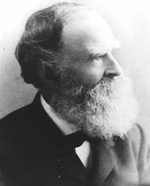 |
Samuel Boneham |
Samuel Boneham was born at Thornborough in 1817, and married Jane Mumford at Winslow in 1838. In 1844, there was an advert in the Bucks Herald for the sale of the farming stock of Mr Samuel Boneham of Thornborough Field Farm, which also included 70,000 draining tiles and 20,000 plain tiles. He used the money to buy some land in Winslow from the brickmaker Richard Staniford, and apparently continued the brick and tile business. He sold some of the land and used the rest to build 14 houses (now 89-115 High Street; see above) and a pub. These were mortgaged for £500 and insured for £800. The fire insurance policy refers to:
six Cottages under one Roof, Brick built and Tiled ... six Wood Barns under one roof detached near in the same tenures Brick built and Slated ... eight Cottages under one Roof, adjacent ... Brick built and Slated at present untenanted ... eight Wood Barns ...
It was Winslow's biggest housing development, and filled up the gap between houses built in or before the early 1840s (up to no.87) and the Workhouse. It started too early to be a deliberate attempt to cash in on the arrival of the railway, but in 1851 the occupants included John Braggins (railway porter) and Thomas Upton (rail labourer); most of the others were shoemakers and agricultural labourers. Winslow hadn't previously had purpose built "artisans' and labourers' dwellings". In 1848 Mr Boneham advertised:
TO LET, with immediate Possession, that Newly Erected BEER HOUSE, known by the sign of the “ROYAL ENGINEER,” at Winslow, now in the occupation of Mr. John Law.
but he was living there himself by 1849, and in the 1851 Census he was described as a butcher. He also rented a farm from William Selby Lowndes, but got into difficulties and his property was in the hands of trustees by 1853.
Oxford Chronicle, 10 Nov 1855
The series of misfortunes, of which Mr. Samuel Bonham, of this town, has been the victim, have enlisted the sympathies of his friends and neighbours who are generously subscribing for the purpose of paying the passage of himself and family, consisting of a wife and eight children, to Australia. Mr Neal, of the Bell Inn, has kindly consented to receive the subscriptions.
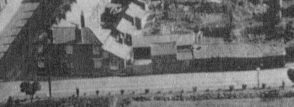
He actually emigrated to Canada, moved to the USA in 1863, had a business as a florist, and died at Friends Creek, Illinois in 1896 (thanks to contributors to ancestry.com for this information and the photo). The photo below shows the former Royal Engineer, with extensive outbuildings, in 1931 (it was demolished in 1959):
Robert Crockett, stone mason, was buried in 1770. According to the 1770 manor court he held "a Messuage in Winslow now in the occupation of William Crockett; 2 little pieces of Ground known as the Pightle adjoining". He died, having made his will dated 2 Aug 1770, in which he devised them to his wife Mary and son William Crockett, who desired to be admitted.
The Pightle was acquired by Henrietta Tookey 1789-96. She and her husband John Tookey sold it to Richard Staniford, brickmaker, in 1809. It was then acquired by Samuel Boneham.
The land on which the Boys' School and Gasworks was built was called Crockett's Close. It was owned by John and Mary Morecraft in the 1840s, and they sold off more pieces of it in 1844. It extended further north, probably as far as the site of no.81.
The Boys' School also used part of Jennings Close.
