- Home
- News / events
- Avenue Road
- Biggin
- Buckingham Road
- Census 1841
- Chapels
- Charities & poor relief
- Church
- Church Street
- Directories / descriptions
- Enclosure
- Families / people
- Farms
- Fire insurance
- High Street
- Horn Street
- Maps
- Market Square
- Medieval & 16th century
- 19th-20th Centuries
- Oral history
- Parish Council
- Photographs
- Pubs
- Railway
- Redfield
- Schools
- 17th-18th Centuries
- Sheep Street
- Shipton
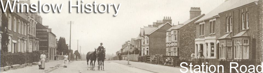
- Station Road
- Tanneries
- Tinkers End
- Turnpike
- Vicarage & Verney Roads
- Western Lane
- Wills
- Windmill
- Winslow Hall
- Workhouse / Hospital
- World War One
- Sitemap
- Links
- Search site
- About us / contact

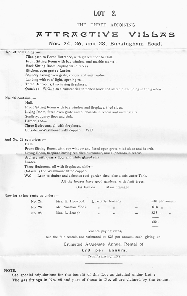
Buckingham Road
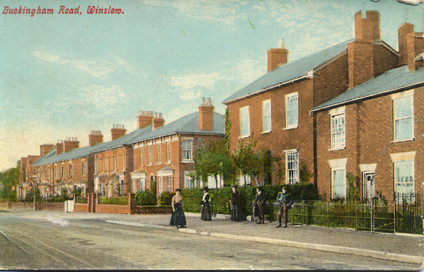
Buckingham Road, showing Nevada Villas and Alwyn House
The present-day Buckingham Road became the main route to Buckingham after the turnpike was created in 1742, but did not develop as a residential area until the mid-19th century after Station Road was built. Before the workhouse was built (and up to the 1861 census), the High Street north of the Windmill / Greyhound Lane was known officially as Buckingham Road.
Selby Villa, sometimes treated as part of Buckingham Road, was built in the 1820s on the corner of Great Horwood Road.
The Swan was built in 1850-51 to take advantage of the railway trade. The adjacent houses up to Alwyn House (no.8) were probably part of the same build, and certainly existed by 1856. Originally there were three cottages between The Swan and Alwyn House but one was incorporated into The Swan, probably in the 1890s. The advert below refers to nos.4-6 and the cottage which became part of The Swan (Bucks Herald, 30 Aug 1873). They were bought by Charles Chaplin and bequeathed to his wife Joanna in 1876.
THREE BRICK & SLATED FREEHOLD COTTAGES, WITH GARDENS, &C.,
Situate in the most pleasant part of the Buckingham Road, and near the Railway Station,
TO BE SOLD BY AUCTION, BY
DUDLEY & SON,
On WEDNESDAY, the 17th of SEPTEMBER, 1873,
AT THE BELL INN, WINSLOW, at Four o’Clock in the Afternoon.
THE PROPERTY comprises THREE Substantially Brick-built and Slated FREEHOLD COTTAGES, with Front and Kitchen Gardens and Woodhouses, very pleasantly situate with a southern aspect in the Buckingham Road, and near the Railway Station, in the occupation of Messrs. Charles Chaplin, Thomas Cullum, and -------, at rents amounting to £22:4 per annum.
For a view apply to Tenants; and for further particulars to Messrs. Watson and Son, Solicitors, Aylesbury; or Messrs. Dudley and Son, Auctioneers and Land Agents, Winslow.
Apart from those, the houses on the east side of the road were built piecemeal from 1875, when the land (formerly Black Bush Furlong) was sold in 14 separate plots (see sale advert), including 4 where Courthouse Close is now, to be reached by the lane next to Alwyn House (Centre for Bucks Studies, D-WIG/2/7/1878/2). Of the plots fronting Buckingham Road, the purchasers were:
Lot 15
(now nos.10-16): Mr George Gibbs
Lot 16-17 (now nos.18-28): Mr E.J. French
Lot 18 (now nos.30-32): Mr F. Roads
Lot 19 (now part of no.34 and Mill Close ): Mr G. Dunkley
Lot 20 (now part of no.34 and Mill Close): Mr J. Clare
Nevada Villas (now numbers 10-16) were built soon afterwards. Two of them were offered for sale in 1881 (advert from Buckingham Advertiser, 27 Aug):
BUCKINGHAM ROAD, WINSLOW.
Two Semi-detached VILLA RESIDENCES with Gardens, &c. Attached to one is a large Yard, Buildings and Premises, suitable for the business of a Builder, or any business where space is required; situate on the Buckingham Road, within five minutes walk of the Market Place in Winslow, and the same distance from the Railway Station.
GEORGE BENNETT
Is instructed by the Mortgagees under the power of Sale to Sell by Auction, at the Bell Hotel, Winslow, on WEDNESDAY, the 31st day of August, 1881, at Five o’clock in the afternoon, in one Lot, and subject to such conditions as will be then read.
ALL THOSE TWO SEMI-DETACHED
R E S I D E N C E S,
CALLED Nos. 1 and 2, Nevada Villas; one now in the occupation of Mr. G. Gibbs the other of Mr. William Trew. The HOUSE occupied by Mr. G. Gibbs, has Entrance Lobby, Parlour with bay window, Sitting Room, Kitchen, Cellar, three Bedrooms, &c., small Room used as an office, and in the rear are Yard, Workshops, Shed, Stable, &c., with Carriage Entrance from the road, also a large and productive Garden. Estimated Rental £25 per annum.
The HOUSE occupied by Mr. William Trew contains Entrance Lobby, parlour with bay window, Sitting Room, Kitchen, Cellar, and Three Bedrooms, together with the usual Outbuildings and small Garden: Rent £15 per annum.
These Houses are pleasantly situate with an uninterrupted front view, and stand a convenient depth from the road, having small Gardens in front, enclosed with iron railings.
There is a Good supply of Water.
The Premises are Brick-built and Slated, and have a frontage of about 50 ft. and a depth of 254 ft.
The Tenure of the Property is Freehold.
For further particulars apply to Messrs. Hearn and Langdon, Solicitors, or the Auctioneer, Buckingham.
A full description of two of them can be seen in the sale catalogue from 1909 below (click on the images for full size):
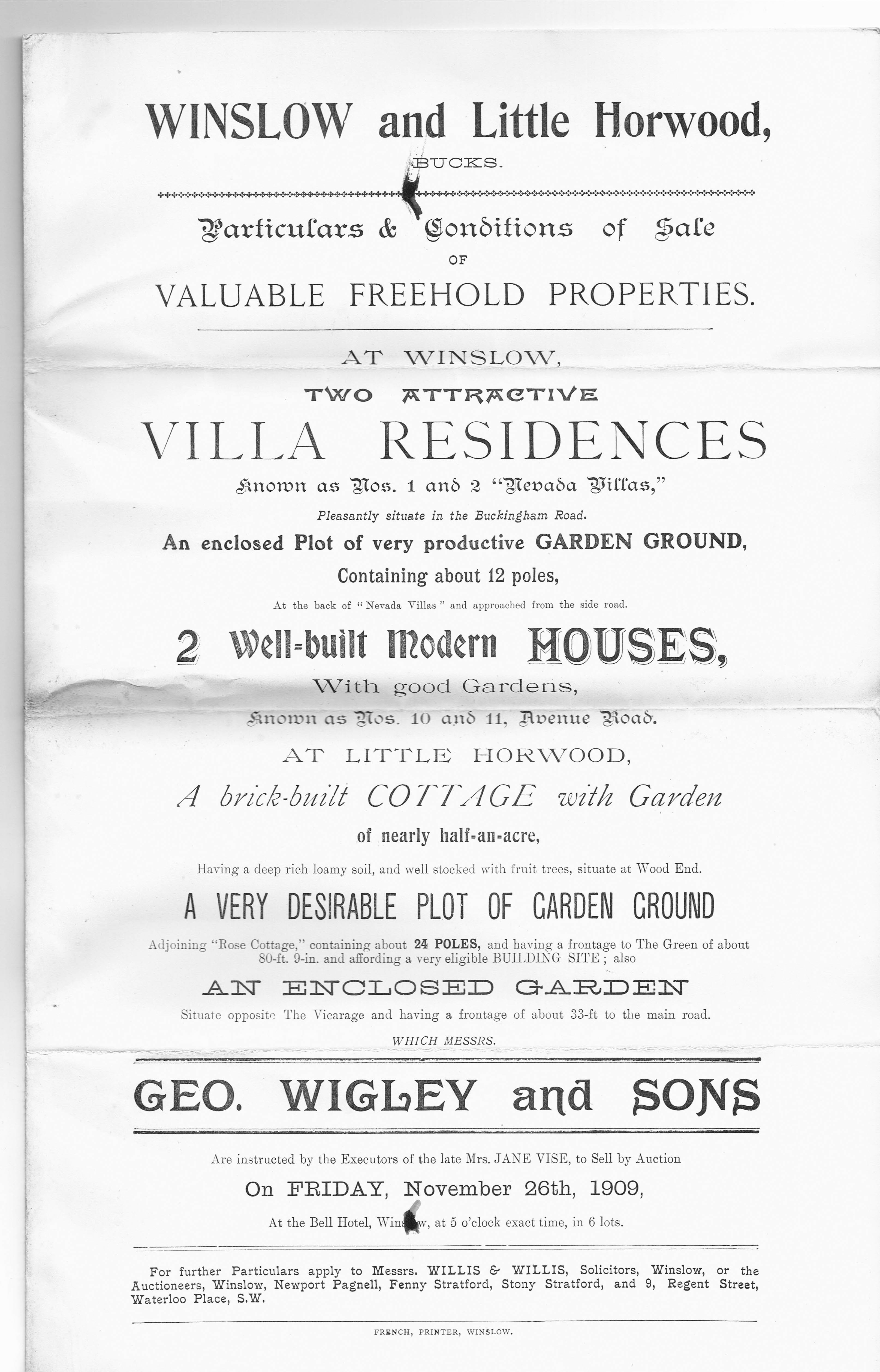 |
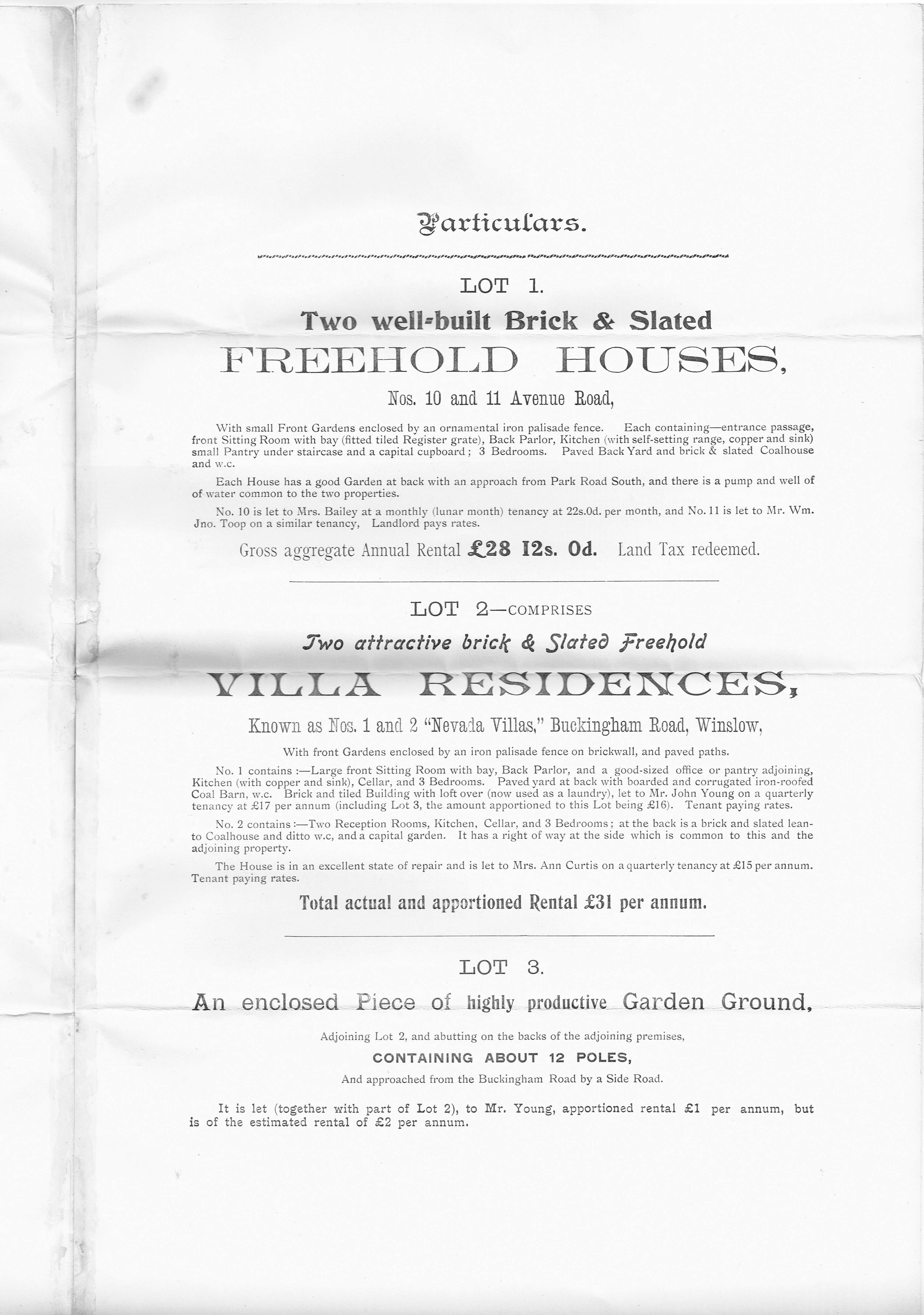 |
 |
The "garden ground" which was sold at the same time is now Courthouse Close.
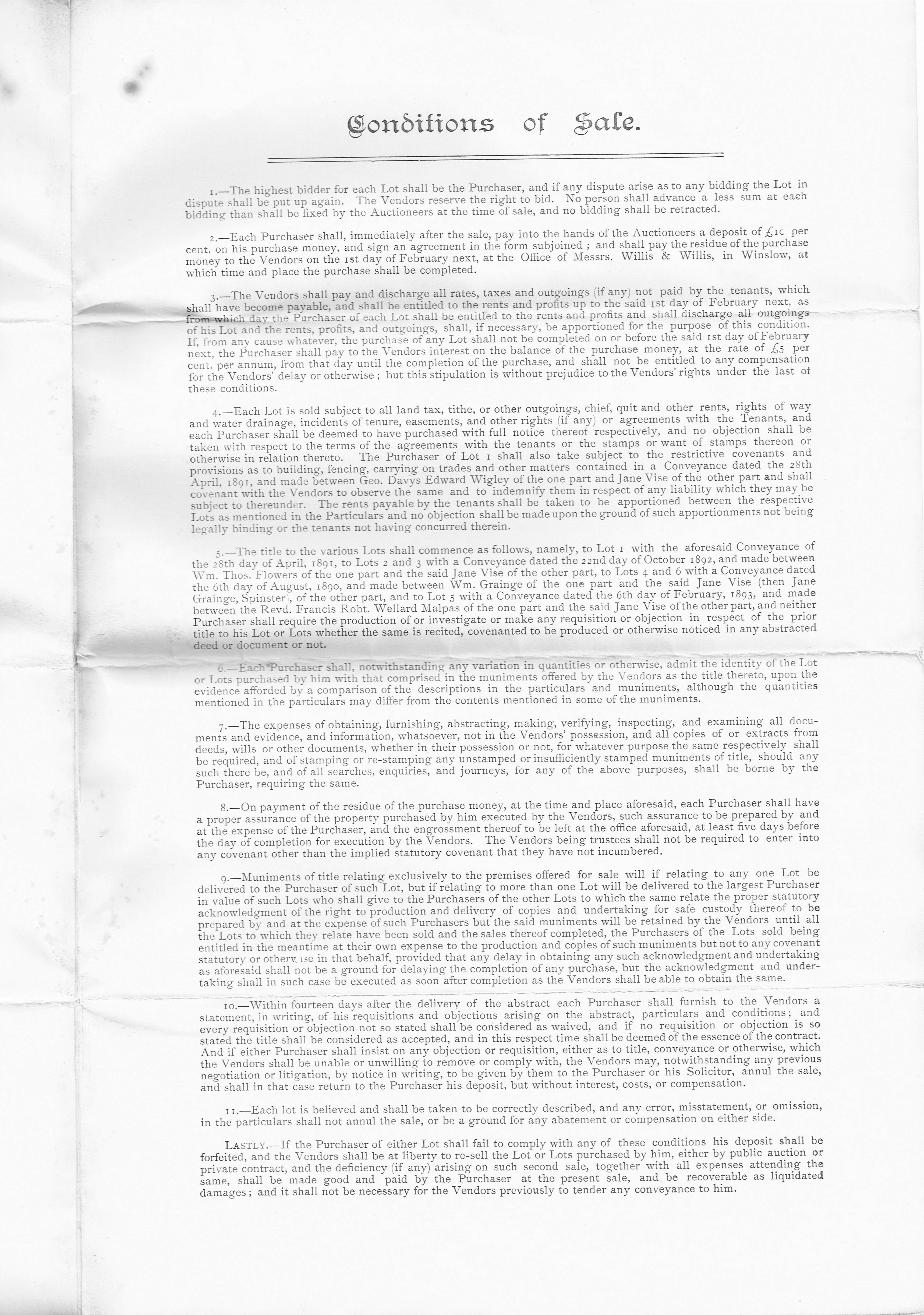
The houses called The Beeches (now numbers 18-28; the furthest block in the photo above) were built in two lots: nos.24-28 predate the 1881 Census and can be seen in a photo taken from the church tower c.1885 (see Avenue Road) but there is a gap where nos.18-22 later appeared. They were purchased by John Clarke in 1892, and sold by his executors in 1937. They are described in the sale catalogue below (click on the images for larger versions).
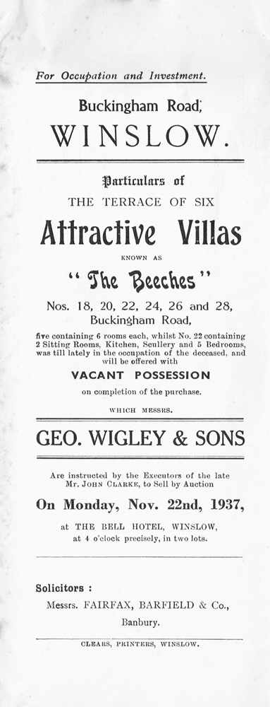 |
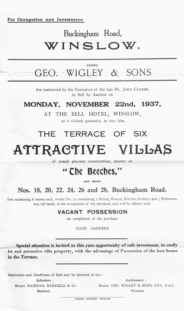 |
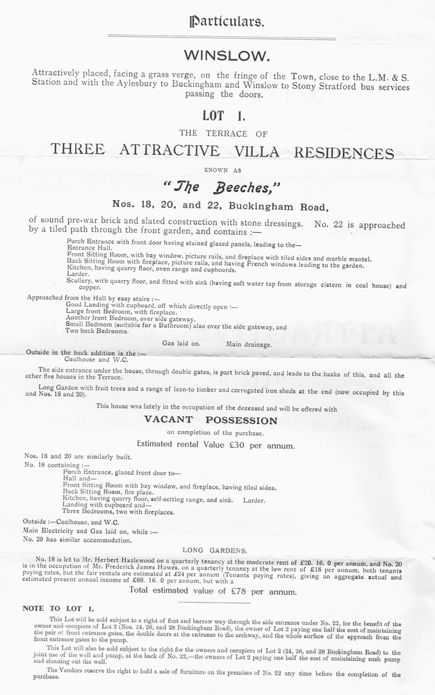 |
 |
Two large houses (numbers 30-32) were occupied in the 1881 census by the extensive family of Arthur Stead Midgley (solicitor's clerk) and by John Lamburn, a retired farmer; eight other households were recorded in 1881 including Dr Henry Collins at Alwyn House, and three were being built. There were 14 in 1891.
Number 34 was the hunting box of Sir Robert Abercromby, later replaced by the Town Mill.
1895: Buckingham Advertiser, 23 Nov
Winslow Town Mill.
By advertisement in another column it will be seen that Mr. John Buckingham has re-opened the capacious premises known as Sir Robert Abercrombie Stables and situate in the Buckingham Road, as a flour mill. As far back as 1326 Winslow possessed a mill, and in later years, two, there being the “Old Mill Field” and the “New Mill Field,” the latter being what is now known as “Mill Knob,” of the older mill no traces are known, but the latter one appears to have been burnt down in 1760. These old mills were driven by the wind [this was later corrected by Arthur Clear to point out that the old mill was a watermill], but Mr. Buckingham’s mill is driven by a motive power, as yet strange to the general public, and absolutely unknown to our forefathers, viz., paraffin, or more correctly speaking paraffin-gas, and respecting which a little information may not be out of place. Mr. Buckingham’s engine is of 10-horse power nominal, but will work up to 18-horse, and is by the celebrated firm of Crossley’s, of Manchester. It is on very much the same principle as the gas engine- a certain amount of paraffin being pumped into chambers at the rear of the cylinder- ait is then forced into it, and the whole coming into contact with a red-hot bar explodes, and this explosion in the cylinder forces the piston forward, the reciprocating motion being kept up by the fly wheel, which weighs 18 cwt; it will work up to 200 revolutions per minute, and consumes about ten pints of paraffin per hour. Mr. Buckingham is having his mill well fitted with every convenience for doing a large and quick trade (the work being capitally done by Mr. Dawson, millwright, of Peterborough), and there is every prospect of its being a welcome addition to the trade and convenience of the town.

34 Buckingham Road and the Town Mill
The White House (Selby Villa), beyond the railway bridge, was demolished in the 1930s.
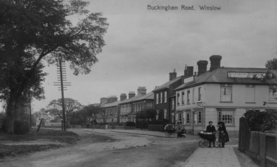 |
Buckingham Road looking north, before the development on the west side |
| Numbers 30-32 | 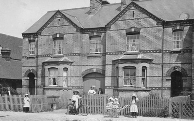 |
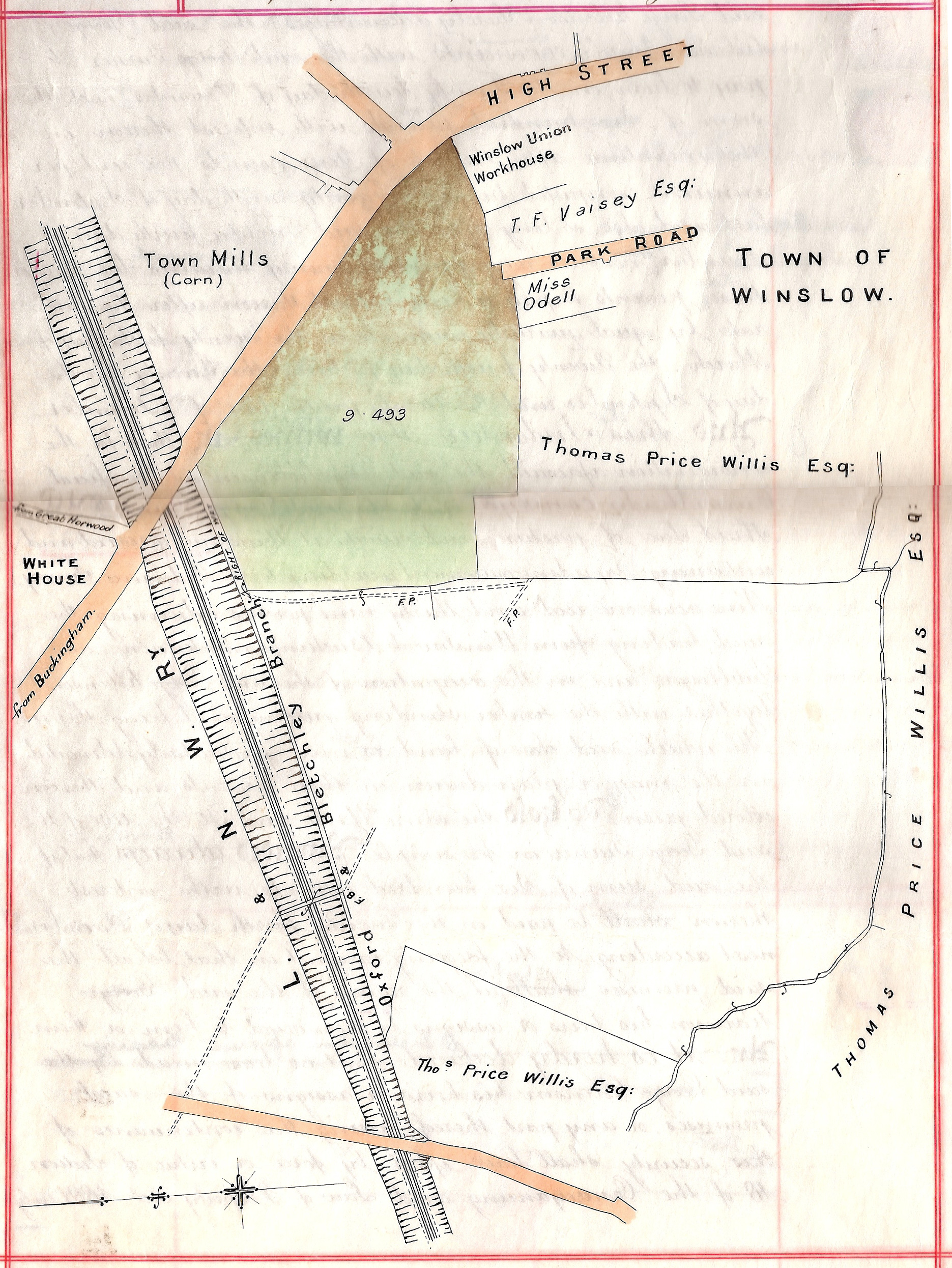
The land to the west was, after enclosure, a close called Gubblesgore. The owners after enclosure were William Aldridge and Benjamin Ingram. It then passed to two more Benjamin Ingrams who lived in Leics. It was offered for sale in 1813. Edward Heighton of Leicester bought it in 1825, when it was occupied by John Arnott. A small part was sold to the Bucks Railway Company. Later owners were the Selby-Lowndes estate (William Selby Lowndes bought from Edward Heighton in 1842 a lot in New Mill Field containing 5a 3r 34p "now known as part of Gubbles Gore" late in the occupation of John Arnott now of James Hawley) and John Maydon of Moggerhanger. It was for sale as building land in 1865. It remained as pasture until after the First World War. The Parish Council looked into renting some of it from John Maydon in 1899 for a recreation ground but couldn't reach an agreement. The plan below shows the layout of the area in 1906 (see below for details of the sale), when it was bought by George Robinson of the Swan, who was already the tenant. Pieces of the land were sold off for development from 1920, when Harry Cripps the highway surveyor bought the plot of the house now called Gubblesgore. The first stage of the development can be seen in an aerial photograph.
Click on the image for the full plan (East is at the top). This document, and others relating to the close called Gubblesgore going back to 1766, have been donated by Alan Goodgame and are now in the Winslow History Archive in the St Laurence Room. |
 |
Buckingham Advertiser, 16 June 1906
|
Messrs. GEO. WIGLEY & SONS |