- Home
- News / events
- Avenue Road
- Biggin
- Buckingham Road
- Census 1841
- Chapels
- Charities & poor relief
- Church
- Church Street
- Directories / descriptions
- Enclosure
- Families / people
- Farms
- Fire insurance
- High Street
- Horn Street
- Maps
- Market Square
- Medieval & 16th century
- 19th-20th Centuries
- Oral history
- Parish Council
- Photographs
- Pubs
- Railway
- Redfield
- Schools
- 17th-18th Centuries
- Sheep Street
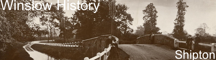
- Shipton
- Station Road
- Tanneries
- Tinkers End
- Turnpike
- Vicarage & Verney Roads
- Western Lane
- Wills
- Windmill
- Winslow Hall
- Workhouse / Hospital
- World War One
- Sitemap
- Links
- Search site
- About us / contact

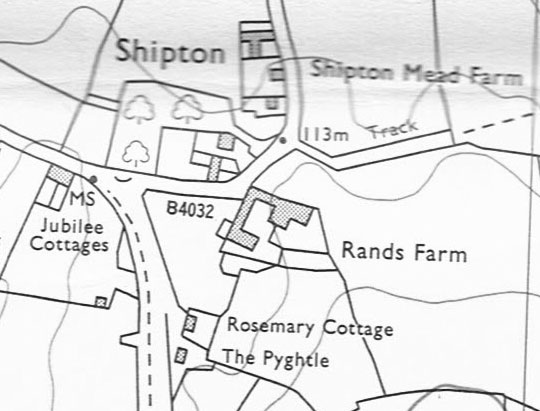
Shipton
The hamlet of Shipton is mentioned by that name in the Hundred Rolls of 1279 (although A. Clear, The King's Village in Demesne, p.42, says it already occurs in charters of Henry I and II). As it had its own field system, it must have existed as a separate community by the 10th century, and it probably corresponds to Lygetun in the charter of 792. It was included with Winslow in Domesday Book, and became part of Winslow parish. It was treated as a separate unit in the medieval Court Books, and appears to have had a similar sized population to Little Horwood and Granborough. In the 1522 Certificate of Musters, 21 names of householders were listed under Shipton compared to 21 for Granborough and 28 for Little Horwood. Its three open fields (Licehill, Red or Varnham and Blackgrove) can be seen on the Fortescue map of 1599.
Some Court Book entries:
1336: Geoffrey Scot surrendered into the lord's hands two and a half acres of land with appurtenances in Schiptonfeld, as they lie in five parcels over Farnham. And the lord handed over the aforesaid land with appurtenances to Richard of Cherdesle.
1370: The lord granted to William Bates a cultivation called Longeheuedelondes lying next to the Cross of Shipton [?the crossroads], to hold for himself and his heirs from the Michaelmas after the date of the court to the end of the next 21 years, paying the lord for it annually 4s on the four usual dates in equal instalments, etc.
1428: Ralph Clerk surrendered into the lord's hands 7 acres of land in the field of Shypton in various parcels, of which a half-acre lies at Shiptonbrygge; a half-acre lies at the Lowe; a half-acre lies at Thorne; a half-acre lies in Reton; a half-acre lies at Brodelytuldon; another half-acre lies in the same place; a half-acre lies at Elledlayne; a half-acre lies at Shortbenehulle; a half-acre lies at Fletelonde; a half-acre lies at Farenhamden; a half-acre lies below Hiestre; a half-acre lies over the Slo; another half-acre lies in the Croft; another half-acre lies in the same place with part of a hedge there and between the land of William Boton and the king's highway. And the lord granted all the aforesaid lands with appurtenances to John Evresdon, to hold for himself and his heirs in villeinage, at the lord's will, through services, etc. Fine: 7s.
 Three upright skeletons were found when digging a sandpit on Rands Farm, c.1930, possibly from a burial mound. A ghost known as "Sieve-Guts" was believed to haunt the area, representing an oral tradition that a battle took place there in the Saxon period.
In 1633, Richard Snow entailed 67.5 acres of land to his daughter Katherine, wife of Ralph Phippes, and her heirs. Most of the land was in Shipton, and the court records provide a detailed list of furlongs in each of Shipton's three fields: see the full document.
A lot of property in Shipton was mortgaged in the late 17th century (and eventually acquired by William Lowndes). For example (Centre for Bucks Studies, BAS 376/22 no.5), in 1671 John Snow mortgaged to Francis Glenister for £40 at 6% interest his messuage and close in Shipton and 4 acres of arable land and meadow in the three fields: Blaclgrove Feild (Housham, New leane furlong, Reden furlong), the Redd Feild (Amersland) and Licehill Feild (Drymead). He paid off the mortgage the next year. In 1669 he had mortgaged the same property to Thomas Smalbones (ibid. no.17), in 1670 he mortgaged another 20 acres in Shipton to Abigail Busbey, widow (ibid. no.21; this is endorsed as discharged), and in 1671 he mortgaged a messuage and 4 acres to Francis Glenister (ibid. no.55). John Snow (who by then lived at Singleborough) sold all his property to Rev. Edmund Sharrock in 1672 for £306. In 1676, Richard Phipps mortgaged all his land, about 10 acres, to Joan Williatt of Great Horwood for £50 + interest; the mortgage was evidently transferred to Robert and Matthew Adams of Swanbourne and only discharged by Richard's son Richard Phipps in 1695 (ibid. no.38).
In 1730 there was a dispute between the inhabitants of Shipton and the Vicar of Winslow about their obligation to pay "tithe milk": see the full document.
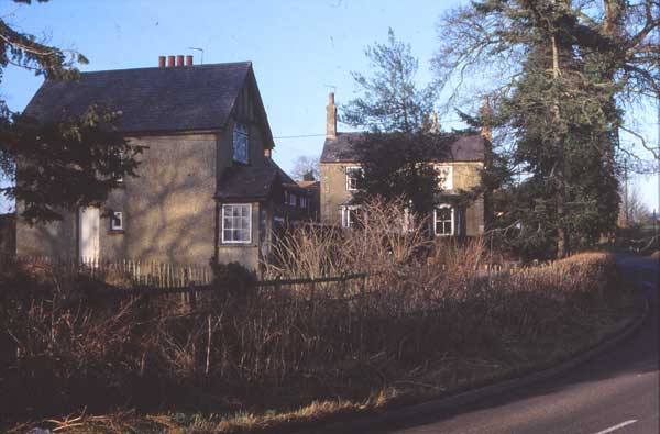
Shipton was enclosed by act of Parliament in 1745, and that appears to have led to depopulation. Only Rands Farm retained its function as a farmhouse; its land was most of the former Blackgrove Field. Red Hall Farm was created in the middle of what had previously been open fields: Red Field and Shipton Cowpasture. Other former farmhouses now became labourers' cottages. Two of these survive as Grade 2-listed buildings:
- Rosemary Cottage is a 17th-century timber-framed thatched 2-bay house with brick infill on the ground floor and plaster on the first floor.
- The Pyghtle is a 16th-century timber-framed thatched 3-bay house with herringbone brick infill. It has a Royal Exchange fire insurance plaque. It was the home of the Elliott family (see the will of William Elliott, 1737), but later became part of the Winslow Hall Estate and was divided into two labourers' cottages.
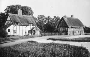 |
Rosemary Cottage and The Pyghtle after the realignment of the main road |
About five more house platforms were visible in 1971 on the same alignment, which is where the road to Swanbourne originally ran; they are less easy to identify now. There were at least six more houses on the brow of the hill, one of which had stone mullioned windows (Clear, p.117). Many of the former farmhouses fell into decay (see below), and one was used as a "pest-house". Three surviving ones were demolished in 1932 when the road to Aylesbury was widened.
Shipton had its own baker for a time: Robert Watson was in business until he died in 1817 (probably at Rosemary Cottage):
Northampton Mercury, 12 July 1817
Copyhold Estate, Household Furniture, and Effects, On Friday the 18th Day of July, 1817, on the Premises of the late Mr. ROBERT WATSON, at SHIPTON, in the Parish of WINSLOW, Bucks. THE HOUSEHOLD FURNITURE, &c. comprise tester and stump Bedsteads, feather and flock Beds, Sheets, Blankets, and Coverlids; mahogany and oak folding Tables, tea and other Tables; Windsor and flag Chairs, Clock and Case, Barometer, swing Glass, japanned tea Tray, oak Cupboards, Chests and Boxes; Earthenware and Glass, kitchen Requisites in Copper, Brass and Tin; large dough Trough, and small Ditto, flour Sieve, Scales, Weights, and Tins; upwards of 200 furze Fagots, with various other Effects. The Sale will commence at Eleven o’Clock precisely. Also, at Five o’Clock in the Afternoon, at the Greyhound Public House, Winslow All that COPYHOLD MESSUAGE or TENEMENT, situate at SHIPTON aforesaid; comprising a good sitting Room, Kitchen and Bakehouse, with Oven complete; three sleeping Rooms; large wood Barn and Shed, with small Garden in front, and a Close of rich pasture Land, adjoining the said Premises, containing together about two Acres, more or less, late in the Occupation of Mr. Robert Watson, deceased. - Immediate possession may be had. For a View, apply on the Premises, and for further Particulars, to Mr. CHARLES WILLIS, Solicitor; or the AUCTIONEER, both of Winslow. |
Northampton Mercury, 13 March 1824
|
BAKEHOUSE AND CLOSE, On Thursday the 18th Day of March, 1824, at the George Inn, Winslow, between the Hours of Five and Six o’Clock in the Afternoon, ALL that substantial brick-built MESSUAGE or TENEMEMT (sic), situate at SHIPTON aforesaid; comprising a good sitting Room, Parlour, and Bakehouse, with a newly erected Oven, capable of baking eight Bushels of Bread, with Barn and Stable, large Garden, and Yard, with a Pump of good Water; also a Close of rich pasture Ground adjoining, containing about one Acre (more or less), now in the Occupation of Mr. Robert Bignell. For a View of the Premises, apply thereon; and for further Particulars, to Mr. WILLIS, Solicitor, or the AUCTIONEER, both of Winslow. |
Northampton Mercury, 22 May 1824 [presumably these are the same premises although the details are not quite the same]
|
TO GARDENERS AND OTHERS. On Friday, 28th May, 1824, at the George and Horse Shoe Inn, Winslow, Bucks, between the Hours of Five and Six in the Afternoon, A Substantial brick-built MESSUAGE or TENEMENT, situate in the pleasant Hamlet of Shipton, near Winslow, Bucks; comprising a good sitting Room, Kitchen, Bakehouse, with a newly erected Oven, capable of baking seven Bushels of Bread, three sleeping Rooms, and Attics; Stable and wood Barn, small Yard, with a Pump of excellent Water; also, a fertile Garden adjoining, containing by Estimation, one Acre and a Half (more or less) and well planted with choice Fruit Trees, the Whole in the Occupation of Mr. WILLIAM KEYS, the Proprietor. The Premises are Copyhold of Inheritance, held of the Manor of Winslow, with its Members, and nearly equal in Value to Freehold, being subject to a Fine of five Shillings only on Death or Alienation. For a View of the Premises, apply to Mr. KEYS, of whom further Particulars may be had; also of Mr. CHARLES WILLIS, Solicitor; or the AUCTIONEER, both of Winslow. |
Northampton Mercury, 15 Aug 1829 [apparently the same premises now available to rent]
|
To Bakers. A DWELLING HOUSE, BAKEHOUSE, and Oven, together with two wood Houses, and extensive Garden and Yard, opening into the Turnpike Road from Buckingham to London, situate in the populous Market Town of Winslow, Bucks. Apply, if by Letter, Post paid, to Mr. COXILL, of the same Place. |
There was a substantial purchase of property in Shipton by the Rothschilds in 1863:
Manor court, 9 June 1863
Surrender: Henry Edmund Newell esq. of Gibraltar
Consideration: £4,000
Admission:
Baron Mayer Amschell de Rothschild
- Messuage at Shipton formerly in the occupation of Francis Warner, since of John Harding, Thomas Brown & Robert Bignell, then of John Gray, now of Joseph Bowden [Rosemary Cottage]
- Close of pasture formerly in the occupation of Elizabeth Turner & Joseph Turner, afterwards of John Harding, Robert Sinfield & Robert Bignell, then of Edward Gray, now of Joseph Bowden
- Close of pasture in Shipton containing 2 acres, formerly in the occupation of Richard Shelton, afterwards of Thomas Bowler & Edmund Cox, then of Richard Sharp, now of Joseph Bowden
- Two undivided moieties of a pasture called Horse Mead Piece containing 7 acres 3 roods 4 perches in Winslow, heretofore in the occupation of William Goodman deceased, then of George Cross
- Plot of inclosed land in Grandborough containing 9a 2r 3p formerly in the tenure of John Holland, afterwards of Michael Shirley, since of Edward Dancer, then late of Henry Newman, now of Edward Dickins
- Piece of pasture in Grandborough called Long Breach containing 26a 3r 21p being part of a plot containing 80a 2r 10p awarded to John Walker upon the Inclosure of the open fields
Newell was admitted tenant on 13 May 1863 as devisee of Admiral Julius James Farmer Newell deceased.
See the sale of the same property in 1870; it sold for £2,740.
Joseph Bowden died in 1867 (see his will) and the stock of his small farm was sold:
1867: Bucks Herald, 13 April
S H I P T O N, W I N S L O W.
THIRTY HALF-BRED SHEEP AND LAMBS, useful Nag Mare, Sow and 10 Pigs, Cock of good Hay (to go off,) spring cart, 3 carts, capital harness, milk leads, and the very useful FARMING IMPLEMENTS,
TO BE SOLD BY AUCTION, BY Mr. JAMES KING, On MONDAY, the 15th day of APRIL, 1867, At Eleven o’Clock,
On the Premises, Shipton, Winslow, Bucks, by direction of the Executors of Mr. Joseph Bowden, deceased.
Catalogues may be obtained at the Place of Sale, and of the Auctioneer’s Offices, Winslow.
The house referred to in the following extract seems to be the top one on the 1822 plan below. It was probably demolished because it had been allowed to decay too far to be worth repairing. The 1870 map shows it divided into three.
1894: Buckingham Express, 3 March
A FINE old cottage, tempus Queen Elizabeth probably, or at the latest James I., with a handsome herring-boned gable-end, has recently disappeared from the ancient part of Winslow known as Shipton. It was in all probability the oldest building in the town with the exception of the Church.
1907: Bucks Herald, 16 Nov
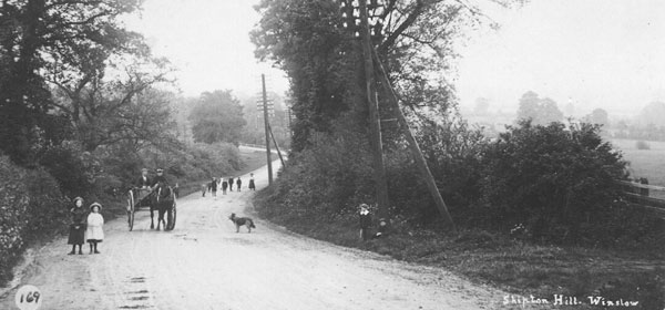
The rage for pulling down antique cottages and houses has, I am glad to note, passed away, in this district at any rate, and it is gratifying to note the spick and span condition (without in any way deteriorating their antique character) in which some of them are kept. For one thing it is difficult to pull some of them to pieces, so strongly are they built. For instance, one in Winslow that was pulled down a few years ago the local builder said might have been thrown from top to bottom of Quainton Hill without doing any material damage to it. There is a capitally preserved specimen of a Tudor cottage with the bricks in between the wooden panels set in herring-bone fashion, just on the brow of Shipton Hill, Winslow, and there are others in the quaintly-named Hobouchin (query abouching - Norman-French) Lane.
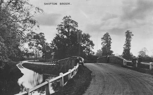
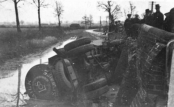
Shipton Bridge was rebuilt with a causeway above flood level in 1792 (see photo above). There was further improvement to the turnpike from Whitchurch to Winslow which involved the demolition of a house and realignment of the road to its present course (see 1822 map below). A drawing from 1835 shows a design for a new bridge which matches what still exists except that it doesn't show the cutwaters (Bucks Archives, T3/77). This bridge now forms a lay-by and the main road runs over a modern (1937) bridge to the east. The photo below shows a crash involving the London Co-operative Society's milk tanker in 1932; the old bridge was inadequate for motor traffic. According to the Buckingham Advertiser: "the tank, which was going in a southward direction, arrived at the bridge at the same time as a large six-wheeled lorry, proceeding northwards. Crashing through the parapet of the bridge, the tank fell on its side in the stream... Good fortune favoured the drivers, for neither was seriously hurt... There was a very considerable loss of milk, the stream being filled with gallons of it."
In the 1841 census, excluding farmers, there were 14 households in Shipton with a total of 75 occupants, an exceptionally high density in Winslow. In 1851, Shipton had seven cottages in "London Road" and four in "Swanbourne Road" occupied by labourers and lace-makers. There were also two farmers (Thomas Edwin at Rands Farm and John Woodward at Redhall Farm), one proprietor of land (Thomas Clark) and one grazier (Ann Burgess).
In 1891, there were eleven labourers' cottages on the north side of Swanbourne Road, and nine more along the main road - perhaps some of this was due to sub-division of the existing houses. The Cottage, the last house along Swanbourne Road before Red Hall Farm, was occupied by Thomas Woodward, retired farmer. The Pyghtle seems to have been divided in two, occupied by Thomas Foskett (described as a small landowner) with his wife (a laundress), niece and a boarder, and by William Keys, a carpenter, with his wife and 6 children. Edward Collier, school attendance officer, appears to have lived at Rosemary Cottage.
On 24 June 1896, the following properties in Shipton belonging to the late Richard Wilmore were sold by Wigleys (the sale notice is on display in the Bell Hotel):
|
 |
1911: Buckingham Advertiser, 13 May
POST OFFICE TELEGRAPHS.
PURSUANT to the Provisions of the Telegraph Acts, 1863 to 1909.
NOTICE IS HEREBY GIVEN, that His Majesty’s Postmaster-General, having obtained the consent in that behalf of the body having the control of the PUBLIC ROAD for approximately half a mile along the Swanbourne Road from its junction with the Winslow, Aylesbury Road, Shipton-cum-Winslow, intends to place a TELEGRAPH over and along the said public road and for that purpose to erect and maintain posts in and upon the said public road under the powers conferred on him by the Telegraph Acts above-mentioned.
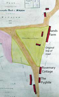 |
This plan dating from 1822 shows how the main road was realigned. Buildings are marked in red. Only the three whose modern names have been added still exist. |
| This house (divided into two) on Swanbourne Road was demolished in the 1930s. The photo shows how the timber-framed farmhouses fell into decay when they lost their original function after enclosure. | 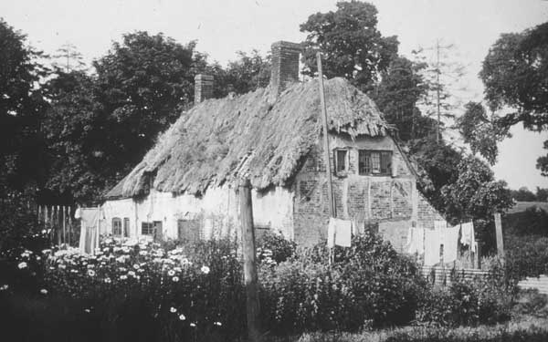 |
| The Housing Act of 1930 encouraged local authorities to demolish and replace poor housing. The minutes of Winslow RDC for 10 Feb 1933 (CBS, DC4/1/10) state that the surveyor recommended demolition of a house at Shipton owned by Mr R.A. Wilmore, presumably the one pictured above, but this was adjourned until the tenant left. On 13 April his brother-in-law Mr W.J. Syrett attended the council meeting and the demolition was adjourned. Wilmore and his sister Mrs Syrett wrote to the council about the limited repairs he was willing to make to the house "as an old thatched cottage". Demolition was adjourned again but must have followed soon afterwards. | |
 |
These cottages next to Swanbourne Road, photographed in 1989, were demolished in the 1990s to be replaced by larger new houses. |
| This view looking south (c.1910) shows Rosemary Cottage and the Pyghtle on the left and one of the demolished cottages on the right. | 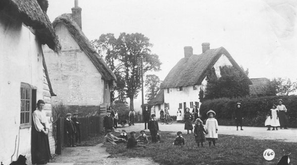 |
 |
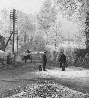
These two photos looking down the hill towards Shipton Bridge from roughly the same position show some of the changes made by the road improvements in 1937. The lower one was taken in 1966. |
 |
In 1934, some skeletons were found by workmen near Swanbourne Road (North Bucks Times, 17 April 1934):
SHIPTON SKELETONS FOUND.
A SAXON RELIC?
RURAL GHOST STORY.
A great deal of interest has been aroused in Winslow by the discovery of a number of human skeletons in the sandpit at Shipton. The top layer is a heavy clay and a workman digging about four feet below the face, saw what he imagined to be a section of a drain pipe and drove his pick into it only to find that he had split a skull. Further investigation revealed the remains of at least four bodies The jaw-bones have complete sets of strong teeth in them, and one appears to have belonged to a man of great strength. Another is that of a youth who had not yet cut his wisdom teeth. The police were informed and a Home Office official was asked to investigate.
The supposition is that these remains date back to Saxon days. Winslow is place of great antiquity and at one time belonged to Offa, King of Mercia, who about the year 790, founded the Abbey of St. Albans and gave his Manor of Winslow to that church, in whose hands it remained till the Reformation.
Among many possible derivations of the name Winslow, one that has been suggested is 'Winnesh law," the mound of battle. Mr. Arthur Clear in his "History of the Town and Manor of Winslow" says: "If we accept this we would suggest that the spot so long known as the Red Field, in the hamlet of Shipton, may, perchance, mark the very site where, in days of yore, some fierce encounter took place between the early British inhabitants and a body of West Saxon invaders."
Near this spot is a little brook which long bore the strange name of "Bubbler's Gore." This name has long been forgotten. but it has been surmised that Bubbler is a corruption of Bubba, the name of a Saxon chief, and that it is remembered as having run red with blood in some great struggle. However true that may be, it is interesting to speculate on the strange persistence of names and the traditions enshrined in them.
It was near this brook, now shrunk to very small dimensions, that a Winslow ghost was once said to walk. There are still to be found, people in the town who can remember being terrified as children, by the tales of this spectre, who was said to have the extremely unpleasant habit of carrying his own entrails on a sieve. No explanation of his unpleasant manners appears to be forthcoming, but he seems to have been a harmless creature, and was familiarly known - with that simple directness, characteristic of rural England - as "Old Sieve Guts." He seems to have definitely retired from business when the "Jubilee Cottages" were built, nearly fifty years ago. Perhaps Victorian architecture was too much for him.
See also:
- Shipton Conservation Area Review (2008) - a thorough survey of present-day Shipton, from the AVDC website